


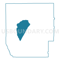
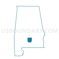
ROCKY CREEK, Butler County, Alabama
About
Outline

Summary
| Unique Area Identifier | 521282 |
| Name | ROCKY CREEK |
| County | Butler County |
| State | Alabama |
| Area (square miles) | 50.04 |
| Land Area (square miles) | 50.03 |
| Water Area (square miles) | 0.01 |
| % of Land Area | 99.99 |
| % of Water Area | 0.01 |
| Latitude of the Internal Point | 31.75221310 |
| Longtitude of the Internal Point | -86.75300610 |
Maps

Graphs
Select a template below for downloading or customizing gragh for ROCKY CREEK, Butler County, Alabama


Neighbors
Neighoring Voting District (by Name) Neighboring Voting District on the Map
- BOILING, Butler County, AL
- CHAPMAN POST OFFICE, Butler County, AL
- FOREST HOME, Butler County, AL
- GREENVILLE NATIONAL GUARD ARMORY, Butler County, AL
- MANNINGHAM, Butler County, AL
- PROVIDENCE, Butler County, AL
Top 10 Neighboring County Subdivision (by Population) Neighboring County Subdivision on the Map
- Greenville CCD, Butler County, AL (13,363)
- Georgiana-McKenzie CCD, Butler County, AL (4,341)
- Chapman CCD, Butler County, AL (1,774)
- Forest Home CCD, Butler County, AL (1,469)
Top 10 Neighboring Unified School District (by Population) Neighboring Unified School District on the Map
Top 10 Neighboring State Legislative District Lower Chamber (by Population) Neighboring State Legislative District Lower Chamber on the Map
Top 10 Neighboring State Legislative District Upper Chamber (by Population) Neighboring State Legislative District Upper Chamber on the Map
Top 10 Neighboring 111th Congressional District (by Population) Neighboring 111th Congressional District on the Map
Top 10 Neighboring Census Tract (by Population) Neighboring Census Tract on the Map
- Census Tract 9531, Butler County, AL (3,023)
- Census Tract 9534, Butler County, AL (2,931)
- Census Tract 9529, Butler County, AL (2,180)
- Census Tract 9533, Butler County, AL (1,774)
- Census Tract 9530, Butler County, AL (1,469)